Dr. Billy Fields, Associate Professor in the Department of Political Science at Texas State University, envisions streets where parks, waterways, and communities meet
Crystal-clear, spring-fed waters flow through Texas State’s campus and snakes through the surrounding city. If you know San Marcos, chances are, you know the San Marcos River. The cooling waterway serves as a habitat for endangered wildlife and a recreation destination for neighboring communities.
The San Marcos River is a perfect example of linking green spaces like parks with blue infrastructure, or waterways. I enjoy the shade from the trees in the summer, the naturally cool spring water that stays at about 70 degrees year-round, and the opportunities to kayak right in the city. And as an urban planner and scholar, I see the potential for linking this green and blue corridor with the rest of the city.
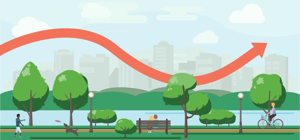
In the wake of COVID-19, there’s been a lot of talk about resilience and bouncing back, but bouncing back implies returning to the status quo. In the transportation sector, my area of focus, the status quo has involved high road fatality rates and pollution that impacts both air and water quality. Rather than bouncing back, urban planners have begun to ask a different question. How should we bounce forward? What if we started to link our cities together with green and blue streets that decrease pollution, calm traffic, and improve quality of life? Rather than waiting for a return to normal, we must envision a better normal.
What makes a city resilient?
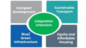
In my book, Adaptation Urbanism and Resilient Communities (Routledge 2021), I explore the question of how cities can bounce forward. By examining lessons from the resilience planning leaders of Copenhagen, London, Miami, New Orleans, and Rotterdam, I found that successful urban resilience projects focus on bouncing forward in four key areas.
-
- Compact cities: Compact cities bring the resources to the people, rather than the other way around. When we put community destinations such as schools, shopping, and parks near affordable housing, people can access their daily needs with short trips—and produce less pollution in the process.
- Sustainable transportation: Walking, bicycling, and public transit provide low-pollution means of accessing community destinations. Since 50% of all trips are 3 miles or less, we should expand sustainable transportation options to better connect people to the resources they need and empower people to lead healthier, more active lifestyles.
- Green and blue connected corridors: The San Marcos River is a great example of the connection between green and blue infrastructure. To prevent street runoff from rushing into the river, bioswales have been added along C.M. Allen Parkway to filter out the pollution and keep the water clean and safe for the community. Creating a network of streets that are adapted to decrease both runoff and traffic makes communities more livable and better connects people to the places they need to go.
- Affordable housing: While new green amenities spur development and improve neighborhood quality of life, they also lead to higher housing costs. That’s why managing the success of new green and blue infrastructure through targeted affordable housing initiatives is vital. Affordable housing options must be prioritized from the beginning of the urban planning process.
 In other words, resilient cities are compact communities with connected green spaces that cool neighborhoods in the summer and soak up water during heavy rains. They are places where people can afford to live near green and blue amenities and travel on accessible streets where it’s safe to walk, bike, and access public transit.
Building resilience through adaptation urbanism
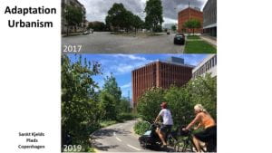
We call this vision for resilient cities “adaption urbanism.” The adaptation urbanism framework is an approach to managing places that better serve community needs while acknowledging that our climate is changing. Adaption urbanism draws from city planning leaders who prioritize livability and pollution prevention. One example of a resilience district comes from Copenhagen, Denmark.
Copenhagen has pioneered new street projects that transform forlorn stretches of asphalt into vibrant urban forests lined by cafes. The photos below show the before-and-after stages of Sankt Kjelds Plads, a residential district in Copenhagen. Urban planners redesigned Sankt Kjelds Plads into a climate-adapted, highly livable green community with increased investment and local shopping.
Texas Success Stories: Trail-Oriented Development
Examples of adaptation urbanism projects are also sprouting up across the US and Texas. Trail-oriented development planning is one way we can adapt the success stories from abroad to a Texas context.
Trail-oriented developments focus on enhancing the amenity value of trails to encourage linear development along trail corridors. In the same way that great parks can spur development and livability, great urban trails can act as catalysts. Connections with traffic-calmed streets link the trails with neighborhoods and lead to improved local retail, housing, and overall livability. Texas cities have been at the forefront of this movement. Dallas’ Katy Trail, for example, has helped to spur revitalization along its 3.5 miles. The planned Hi-Line Connector is poised to become a central link in a planned 50-mile loop around Dallas.
Houston also has a well-developed, radial network of walking and biking trails that flow along its bayous. The planned 150-mile long Bayou Greenway network is becoming a key focus for trail-oriented developments. New developments are sprouting up along the Heights Hike and Bike Trail, also known as the MKT.
The Austin-San Antonio Corridor has also seen a rise in trail-oriented development planning. The San Antonio River Walk is one of the nation’s premier examples of the development potential of blue corridors. The city has taken this legacy project and begun to significantly extend the network up through the revitalized Pearl District with a planned length of 82 miles of trails and greenways. San Antonio’s Comprehensive Plan has developed a trail-oriented development framework for a connected network that will link multiple neighborhoods together in a ring of trails and green developments. The Austin area has also been working to create a linked trail system with the Violet Crown Trail expected to connect Austin with Kyle and potentially down to San Marcos.
Bouncing forward: What’s next?
These examples, as well as others from Atlanta, Indianapolis, Minneapolis, and New Orleans, show the potential of creating green developments complete with trails, greenways, and sustainable transportation. They also highlight the importance of prioritizing affordable housing throughout the development process to avoid displacing existing residents. We need to manage success so that we can build inclusive, resilient cities where everyone can thrive.
To implement these best practices in San Marcos and Central Texas, we must continue to create connected networks of urban green spaces rimmed with appropriate trail-oriented developments. These corridors can then link to neighborhood streets that provide safe connections for walking and biking. The end result? A well-connected and accessible community.
The San Marcos River is already a central community oasis. With trail-oriented development, we can take the next step and bounce forward, making the San Marcos River more accessible and its neighboring communities more resilient.
About the author
Billy Fields (Ph.D., Urban Studies, University of New Orleans) is an Associate Professor of Political Science at Texas State University. His research focuses on understanding the key elements of resilient communities. He is the author of Adaptation Urbanism and Resilient Communities: Transforming Streets to Address Climate Change.